Want to improve your infrastructure? There’s an app for that.
August 17, 2018
![]() For over 15 years, BETA has assisted municipalities in better managing their most valuable asset: their roadway network. Our GIS and Asset Management staff have provided expert assessments and analysis to more than 130 communities throughout New England. Our clients rely on our skills to provide:
For over 15 years, BETA has assisted municipalities in better managing their most valuable asset: their roadway network. Our GIS and Asset Management staff have provided expert assessments and analysis to more than 130 communities throughout New England. Our clients rely on our skills to provide:
- Roadway network assessments
- Capital planning assistance
- Forecast modeling
- Bond assistance and guidance
- Public forum presentations
- GIS support and integration
Building on that solid foundation and expertise, BETA now offers an automated approach to data collections. We have advanced our technology to include the capabilities of RoadBotics, who we have successfully teamed with to provide the latest technology in automated pavement management inspections.
RoadBotics is revolutionizing the way road infrastructure data is collected. By using the latest technological advances in machine vision and machine learning, roadway distress information can be collected quickly and efficiently. This method allows for automated data collection to be conducted in a cost effective manner.
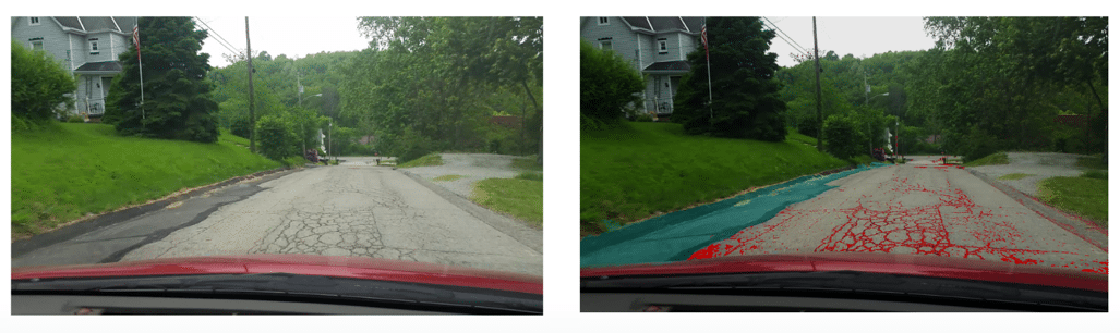
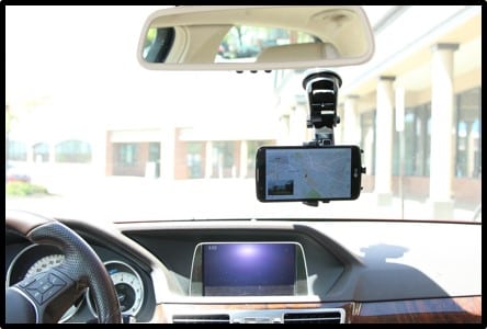 For a recent collaboration, RoadBotics collected raw images using a smartphone affixed to the windshield of a standard passenger vehicle. RoadBotics’ machine learning algorithms then analyzed these images pixel-by-pixel to identify distresses on the road surface. The image on the right shows how the machine learning algorithms automatically identify patched areas (shown in blue) and distressed areas (shown in red). The distresses identified are then analyzed to facilitate the calculation of an industry standard condition rating (0-100 scale).
What sets our team apart?
- Expedited and cost effective data collection
- Automated data collection
- Quality assurance conducted by BETA’s highly experienced pavement inspection teams
- Our web-based platform allows you to see your data the way you’re accustomed to seeing it
- Same reporting/analysis tools (BETA’s ManageMyRoads platform)
- 0-100 rating system
- Ability to customize
- High resolution photographs every 10 feet of your entire road network
- GIS integration
- Proven methods for developing realistic capital improvement plans
Interested in learning more about how our team can provide support to your community? Contact Tony Garro.