
BETA specializes in transforming municipal winter maintenance operations for increased efficiency and effectiveness. Our Route Optimization Program begins with identifying your goals and gathering information on the current state of your operations. By employing advanced GIS tools and techniques, we balance and optimize snowplow, sanding, and main routes for maximum efficiency and safety.
Interested in implementing snow route optimization in your community? Learn more here or contact Tito Sanchez at TSanchez@BETA-Inc.com.
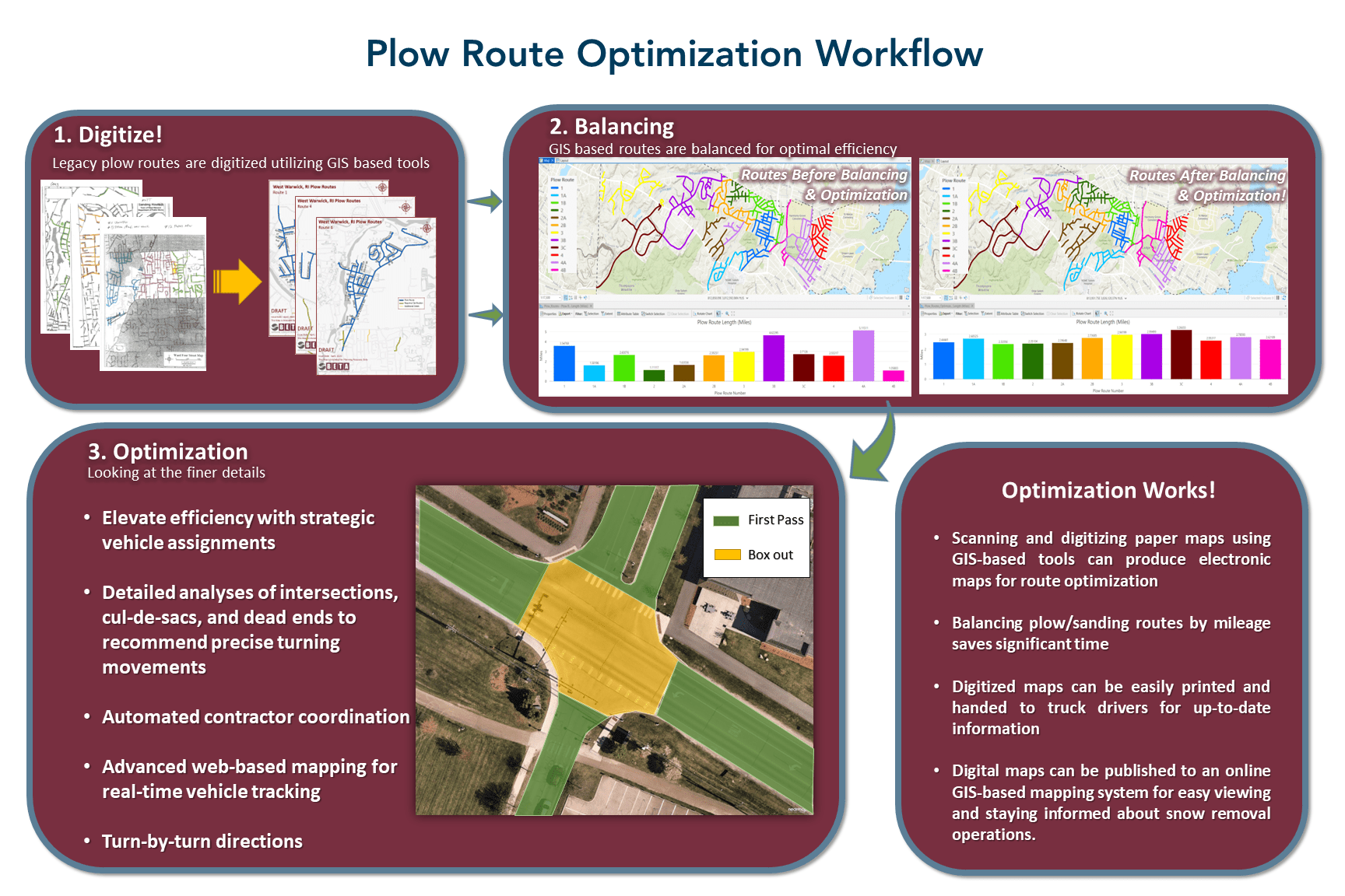
Our three-phase approach, consisting of mapping, balancing, and optimization, has proven successful, as indicated in the following case studies:

Level I: Mapping
Many municipalities often rely on hand-drawn paper maps to organize and visualize their plow, salt, and main routes. This approach can lead to difficulties in reading the maps, especially at night in dimly lit truck cabins. Our approach utilizes GIS-based tools to transform these hand-drawn paper maps into printable PDFs that are easily updated as routes change. This enhances legibility and increases efficiency because drivers can clearly see where they need to clear snow.
Case Study: Milford MA, Plow/Sanding Route Mapping
BETA successfully completed the coordination and mapping updates for the Town’s snowplow, sanding, and sidewalk clearing routes. The project began with a meeting to collect the latest route information, which was then used to generate a GIS database. New maps with an enhanced layout were generated in PDF format, featuring a comprehensive list of streets and designated routes. Additionally, each map now includes a “notes” box, allowing truck drivers to record operational issues or relevant information, ensuring effective communication and efficient clearing operations.

Level II Route Balancing
BETA collects the necessary information to assess a client’s current plow route operations. We then use the latest GIS technology to optimize a municipality’s plowing, sanding, and other routes, aiming to reduce the time required to clear these routes.
Case Study: Franklin, MA Route Balancing
BETA completed the route balancing for the Town’s plowing, sanding, main road, and treatment routes. Using GIS-based tools and winter operations information provided by the Town, BETA optimized the routes for efficiency by balancing them based on lane miles and total clearance time, while also considering travel time from the vehicle storage facility to each route’s start. A new timings spreadsheet was created to showcase the time savings achieved. The balancing process took into account various factors, such as vehicle breakdowns, integration of school driveways and Town maintained buildings into the plow route network, prioritization of mains/hills as primary roads for sanding, and the development of a plan for reallocating or reducing equipment. Additionally, the location of facility snow placement areas on town-maintained facilities was mapped to further enhance operational efficiency. Throughout the entire process, BETA worked closely with the Town’s GIS administrator as routes were refined and GIS-based datasets were shared through an ArcGIS online-driven environment.

Level III: Route Optimization
Route optimization involves looking at the finer details of municipal snow-clearing operations. This will involve assigning and/or reallocating pieces of equipment to ensure that the right vehicle is assigned to clear the right route and is assigned the right piece of equipment for the right job. Optimization also considers clearing operations at parking lots and sidewalks.
Case Study: Wakefield, MA Optimization
BETA completed a comprehensive review of the Town’s fleet of equipment, exploring ways to reallocate vehicles based on their size, road width, and the type of plow associated with each vehicle. The goal was to assist the Town in finding the most efficient use of their vehicles, considering roadway characteristics, and determining the most efficient route for each type of equipment. This analysis helped determine the most efficient methods for clearing each intersection and cul-du-sac, taking into account the type of equipment and the specific plow associated with each piece of equipment, ultimately enhancing the overall efficiency of snow and ice-clearing operations. Optimization allowed the Town to reduce their sanding routes by approximately 2 hours.
Case Study: Sudbury, MA Sidewalk Snow Clearing Optimization
BETA completed a series of mapping and analyses to enhance the Town’s sidewalk snow-clearing operations. First, sidewalks were GPS located along their centerlines at approximately 5-foot intervals, with additional points collected at curb ramps, roadway intersections, and crosswalks. This mapping allows snow-clearing vehicles to identify paths from sidewalk to sidewalk and helps identify possible obstructions such as tree roots, lifted panels, hydrants, and bridge railings.
Following this, BETA developed an ArcGIS Online (AGOL) driven web mapping platform for the Town to view the sidewalk points and related information. The platform is designed with the snow-clearing vehicle in mind, allowing drivers operating sidewalk snow-clearing vehicles to view the web map and its content on a field tablet, with real-time tracking of the vehicle relative to the sidewalk centerline path.
Finally, BETA identified high-priority locations throughout the Town, such as community centers, schools, and public transit stops, which are conducive to high pedestrian traffic. Each location was assigned a Priority Tier Level, and a buffer analysis was conducted to identify geographic areas for each priority location. These priority areas (Tiers A, B, C, and D) are utilized in developing an approach to prioritize sidewalk snow-clearing operations, ensuring that areas with the highest pedestrian traffic are cleared first for safety and accessibility.