March Newsletter – Employee Spotlight, Using LiDAR, and World Water Month
March 14, 2023
Employee Spotlight: Nicole Iannuzzi, PE

With 30 years of engineering experience – the vast majority of that as part of the BETA team – Nicole Iannuzzi, PE has been a large part of BETA’s growth and success. She has instilled institutional knowledge to the site/civil and stormwater groups that she now oversees as Vice President and has played a critical role in some of the largest projects in the State of Rhode Island including:
- South Street Landing and the Wexford Science and Technology Innovation Center projects, both located in Providence
- Assisting RIDOT in meeting the requirements of EPA Consent Decree by implementing two Stormwater Control Plans
- Engineering for the Tanyard Brook Culvert Improvement Project in Bristol, RI
- Town-wide roadway improvement projects for the Towns of Bristol and Narragansett
Click here to read more about her contributions to the firm and her clients!
Using LiDAR for Asset Management
BETA has been using LiDAR to provide cost effective and efficient data collection services for clients throughout New England. LiDAR technology, which stands for Light Detection and Ranging, is a remote sensing technology that uses laser pulses to measure distances to objects and create detailed 3D maps of the environment. LiDAR sensors emit laser beams that bounce off objects and return to the sensor, measuring the time of flight and calculating the distance to each point in the environment.
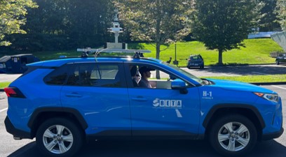
When LiDAR is collected, it creates what is known as a “point cloud,” which is a set of millions of individual points that represent the environment in 3D space. This point cloud can be used to classify roadways, pavement distresses, and other features as well.
The classification of roadway surface distresses using LiDAR technology is possible because different types of pavement distresses have unique signatures in the point cloud data. For example, a pothole will appear as a depression in the point cloud, while a crack will appear as a discontinuity in the surface. Algorithms and machine learning can use these signatures to automatically identify and classify pavement defects, providing agencies with accurate and detailed information about the condition of the roadway surface. Interested in using LiDAR for your asset management projects? Contact us today to learn more!

March 22 is World Water Day!
World Water Day 2023 asks people to “Be the change you want to see in the world.”
Your actions, no matter how small, can help solve the global water crisis. Here are some simple changes you can make to help:
Take shorter showers
Buy local, seasonal food
Turn off the tap
Don’t put waste down the drain
Clean up your local river, lake or beach (keep an eye on our social media accounts to see how you can join us for a clean up project in April during Earth Month!)
Welcome our newest Employee Owner

Joseph Salvato was recently added to BETA’s GIS/Asset Management group as a Geospatial Analyst in our Lincoln office. Joseph earned his Bachelor of Science in Environmental Planning with a minor in Sustainability from Plymouth State University. While earning his degree, he collaborated in developing the proposal of a new open space plan in the town of Plymouth, NH and also successfully completed large projects including mapping stream networks on Mars. Welcome to the team, Joe!
Do you want to become an employee-owner?
We are currently looking for talented staff across many of our disciplines in offices throughout New England. BETA will challenge you with interesting work and offers the potential for growth and advancement. Browse our current job openings.
To start receiving BETA’s monthly newsletter directly to your inbox, please subscribe here.